
Monument Surveying
(925)-470-0101
Monumentsurveying@Gmail.com
SERVICES

Topographic Surveys
A topographic survey is an accurate depiction of a site (property, area of land, defined boundary, geographical features, etc.) which is scaled and detailed to show all the natural and manmade features and elevations. This can be the first step in the design process for a new construction site.

Monument Preservation
California law mandates that all land survey monuments be protected. Monument preservation must be conducted to perpetuate monuments in jeopardy of being destroyed due to planned construction on every public or private sector project.

Survey Letter
A surey letter is required in most counties before the foundation is poured. We can assist with an offical letter per the city or county requirments.

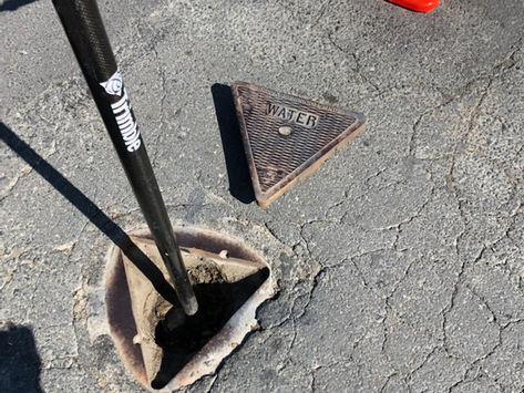
Underground Utilities surveying / locating
As of 2023 section code 4216.3.5 requires all new installation of utilities to be accurately located. We can help meet this requirement for municipalities which fall under this requirement.

Utility Locating
Utility locating services locate
water ,sewer, gas, electric, and communication lines that are underground. Most metallic underground lines can be traced and located. (We are not able to locate plastic and nonmetallic lines at this time).

Property Line services
A survey for the purpose of locating the corners, boundary lines and/or easements of a given parcel of land. This involves record and field research, measurements, and computations to establish boundary lines in conformance with the Professional Land Surveyors Act.

ALTA Surveys
ALTA Survey is a detailed land parcel map, showing all existing improvements of the property, utilities, and significant observations within the insured estate.

Elevation/Flood Certification
A flood certification, is a document that states the flood zone status of real property. Federal Emergency Management Agency (FEMA) flood maps are examined using the address or geographic coordinates of the property.

ABOUT US
We are a family owned and operated Land survey company operating with a licensed land surveyor. Our Licensed land surveyor has over 20 years of experience. Our operations range throughout the bay area as well as serving the central valley. We are a fully operating and insured Corporation with all the necessary permitting.
CONTACT
Contact Us
For any inquiries or questions, please call:
(925)-470-0101 or fill out the following form
Mailing Address
Po box 258
Bethel Island, CA. 94511
Inquiries
Our Licensed Surveyor
Ralph Waller
PLS #9384
BLOG


PROJECTS


